


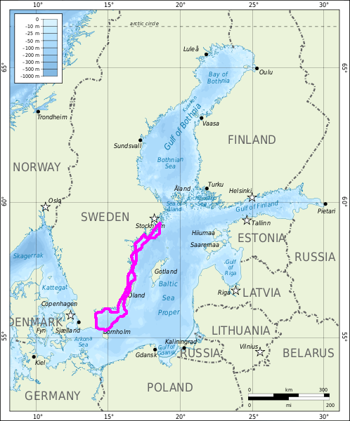
The Baltic Tour 2013 to Karlshamn and Bornholm
This summer SY Isabell sailed Southward. We made it down to the danish islands of Bornholm and Chrisiansoe and back to Stockholm. Follow us in the table below.
First part-going south
Continued PART 2 - Northward bound| Anchorage (date) | Position lat-long at start of day | Distance sailed daytrip(cumulative nM) | Description |
|---|---|---|---|
| Bullandö Marina (20 July) | 59°17.9′N 018°39.0′E | 0 (0) | We start off in the evening . Weather is good, but windy, 11 ms NW. |
| Malma Korshamnsviken (21 July) | 59°14.8′N 018°38.0′E | 3 (3) | Great wind to go south! Nice anchorage in cove protected from NW 11 ms. |
| Söviken,N öja Landsort (22 July) | 58°47.8′N 017°50.8′E | 40 (43) | In our usual spot in the best anchoring inlet in the area. |
| Risö, St Anna (23 July) | 58°24.6′N 016°53.5′E | 42 (85) | Beautiful cove with fine anchorage. |
| SW Fångö Trollholmen (24 July) | 58°10.5′N 016°56.14′E | 27 (112) | Cloudy, wind NE 4-6 ms |
| Krokö, Västervik (25 July) | 57°36.8′N 016°51.03′E | 33 (145) | Cloudy, wind NE 2-4 ms. Misty during the morning. Running lights on. Clearing up later, low winds. Running engine. |
| Stop-over at Blå Jungfrun island | 57°15.3′N 016°47.3′E | 2 hours | Beautiful nature reserve! |
| Sandvik, öland (26 July) | 57°04.3′N 016°51.3′E | 41 (186) | Low winds, had to run engine. But had the chance to anchor at Blue Virgin Island, which was great! |
| Kalmar harbour (27 July) | 56°39.6′N 016°21.8′E | 32 (218) | Lively night in the harbour of Kalmar. Thunderstorm. Shopping and cleaning the boat. |
| Mörbylånga, öland (28 July) | 56°31.7′N 016°22.4′E | 13 (231) | We had high headwind and a choppy sea, with the dinghy in the waves. Rescued the dinghy in harbour cover. 9-12 ms SE. |
| Senoren Norrviken (29 July) | 56°07.9′N 015°46.04′E | 42 (273) | Passed Torhamn and Langoren on the way into the Blekinge archipelago. A known route for Isabell. Beautiful sailing! |
| Karlskrona town visit | 56°10.07′N 015°35.5′E | - | Bunker diesel and go shopping. Touristing the town and visit the Marine Museum. |
| Karlskrona Arpö NE (30 July) | 56°08.6′N 015°25.8′E | 15 (288) | Hasslö bridge opening at 1900 hrs. Rainy evening! |
| Karlshamn, Horsö (31 July) | 56°10.1′N 014°58.9′E | 25 (313) | We forgot to close the hatch, strong headwinds and high waves, rain. Needed to dry all our clothes and stuff. |
| Karlshamn harbour (1 August) | 56°10.1′N 014°51.7′E | 10 (323) | Visited friends and shopping for food. A hot shower, Ahhh! |
| Simrishamn harbour (2-3 August) | 55°33.2′N 014°21.2′E | 51 (374) | In harbour late after a rough ride down. W-SW winds 6-12 ms.We stay an extra day to shop and see the town. The weather turns fair. |
| Tejn, Bornholm Denmark (4-6 August) | 55°14.8′N 014°50.2′E | 36 (410) | Hard headwinds, heavy seas, much ship traffic, but we made it to our farthest destination southwards. After having been chased away by the Danish Coastguard from our route to Gudhjem on Bornholm we end up in the fishing village of Tejn, with a well protected harbour. We decide to stay three nights and visit the coast by foot and buss. |
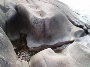
The island Blue Virgin in the Kalmar Sound is a beautiful nature reserve, normally not possible to visit with own boat, since it has no harbour
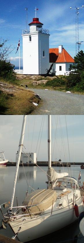
Isabell in the fishing harbour Tejn, Bornholm, the farthest destination of this summers trip
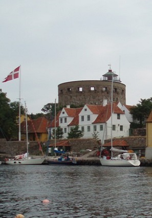
And on the way homeward we stopped at the Danish stronghold Christiansoe, well worth a visit
© Johannes C. Knulst, 2008-2025
From January 2019 this site is upgraded with PHP-version 7.3 and MYSQLi compatibility.
SV Isabell is an excellent long-range sailing vessel for single handed sailing or small family expeditions. Safe, sound, and well built. With a D/L ratio of 342 this 31-foot boat gives a comfortable ride, wherever you sail.
