


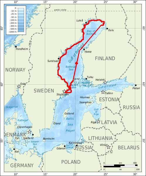
The Baltic Tour 2012 to Vaasa and Haparanda
This summer SY Isabell sailed North. We made it all the way around the Gulf of Bothnia. Follow us in the table below.
First part
Continued PART 2| Anchorage (date) | Position lat-long at start of day | Distance sailed daytrip(cumulative nM) | Description |
|---|---|---|---|
| Bullandö Marina (21 June) | 59°17.9′N 018°39.0′E | 0 (0) | We start off from the homeport at 1015 am. Weather is very good. |
| Söderfjärden Åkersberga (22 June) | 59°27.3′N 018°19.0′E | 14.8 (14.8) | Off to celebrate midsummer |
| no sailing, boat moved (23 June) | 59°28.0′N 018°19.0′E | 0.2 (15.0) | Resting day |
| Vaxholm Marina (24 June) | 59°27.3′N 018°19.0′E | 5.4 (20.4) | Celebrate Birthday |
| Arholma östra hamnen (25 June) | 59°50.5′N 019°07.3′E | 39.8 (60.2) | Preparing for the sea-trip |
| Västerfjärden, Torpön (Åland) (26 June) | 60°10.3′N 019°36.7′E | 33.2 (93.4) | |
| Lökön, Åland (27 June) | 60°22.3′N 019°43.5′E | 29.0 (122.4) | |
| no sailing (28 June) | 60°22.3′N 019°43.5′E | 0 (122.4) | |
| Sea of Bothnia crossing | 29 June – 1 July | 43 hours non-stop | |
| 12 PM position | 61°54.9′N 020°05.5′E | 102.0 (224.4) | |
| 10 AM position | 62°49.6′N 020°20.5′E | 60.0 (284.4) | |
| Langviken, Vaasa (Finland) | 63°03.0′N 021°35.2′E | 52.2 (336.6) | |
| Vasklot harbour, Vaasa (Finland) (2 July) | 63°05.7′N 022°01.7′E | 10.0 (346.6) | |
| Vesterö/Österö, Finland (3 July) | 63°23.0′N 022°01.7′E | 35.2 (381.8) | |
| Bay of Bothnia crossing | 3 July – 4 July | 37.5 hours non-stop | |
| 12 AM position | 63°35.5′N 022°08.4′E | 24.0 (405.8) | |
| 6 PM position | 63°58.3′N 022°34.2′E | 29.1 (434.9) | |
| 12 PM position | 64°23.1′N 023°04.0′E | 30.6 (465.5) | Midnight sun and full moon |
| 6 AM position | 64°38.6′N 023°15.5′E | 26.0 (491.5) | |
| 12 AM position | 65°00.8′N 023°42.6′E | 27.1 (518.6) | |
| 6 PM position | 65°31.1′N 024°24.5′E | 35.0 (553.6) | Sailed into Kemi, Finland |
| Kataja, Finland/Sweden | 65°42.5′N 024°09.3′E | 16.1 (569.7) | Border between Finland and Sweden, Swedens most northeastern island |
| Haparanda harbour, Sweden (5 July) | 65°46.3′N 023°54.4′E | 10.2 (579.9) | |
| no sailing (6 July) | 65°46.3′N 023°54.4′E | 0 (579.9) | Biked to Haparanda and Tornio cities. |
| Haparanda Sandskär (7 July) | 65°46.3′N 023°54.4′E | 13.0 (592.9) | Decide not to go to Törehamn, not worth an extra day of sailing north against the wind |
| Kluntarna, Luleå archipelago (8 July) | 65°27.6′N 022°36.7′E | 34.0 (626.9) | Arrive at midnight, leave at 1630 LT. |
| Rödkallen (8 July) | 65°18.7′N 022°22.3′E | 12.8 (639.7) | Yttre Kassunhamnen, do not try and go into the inner one! |
| Piteå Rönnskär (9 July) | 65°02.2′N 021°33.4′E | 32.0 (671.7) | Super nice! In the lighthouse |
| Tallön, Bureåviken (10 July) | 64°35.5′N 021°19.6′E | 30.0 (701.7) | Heavy fog and rain |
| Bjuröklubb gh (11 July) | 64°28.6′N 021°34.3′E | 17.1 (718.8) | Nice! Free! |
| Ratan (12 July) | 63°59.5′N 020°53.5′E | 44.0 (762.8) | Diesel, nice place. Shower. |
| Djupvik, Obbola (13 July) | 63°41.0′N 020°10.1′E | 43.2 (806.0) | Heavy fog at arrival. Shopping ICA Fyren, 2 km walk |
| Simphamn (14 July) | 63°39.7′N 020°13.9′E | 25.0 (831.0) | After 5 hours of high waves and wind against we gave up and turned into nearest port. |
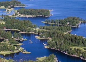
The shallow Kvarken archipelago is the narrowest sound in the Gulf of Bothnia. Part of an UNESCO World Heritage site
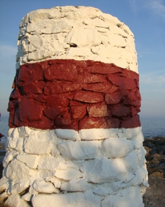
Landmark in the Kvarken Archipelago after two days at sea
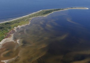
And the sandy reef-like islands of the far North, in the Bay of Haparanda are interesting formations
© Johannes C. Knulst, 2008-2025
From January 2019 this site is upgraded with PHP-version 7.3 and MYSQLi compatibility.
SV Isabell is an excellent long-range sailing vessel for single handed sailing or small family expeditions. Safe, sound, and well built. With a D/L ratio of 342 this 31-foot boat gives a comfortable ride, wherever you sail.
