


The Baltic Tour 2013 to Karlshamn and Bornholm
This summer SY Isabell sailed Southward. We made it down to the Danish islands of Bornholm and Chrisiansoe and back to Stockholm. Follow us in the table below.
Second part-going north
to PART 1 - Southward bound| Anchorage (date) | Position lat-long at start of day | Distance sailed daytrip(cumulative nM) | Description |
|---|---|---|---|
| Tejn, Bornholm (4-6 August) | 55°14.8′N 014°50.2′E | 0 (410) | We stay a few days in Bornholm, to walk around the whole northern coast on the Redningsti trails. Weather is good, sunny and warm, almost Mediterranean. |
| Christiansoe island (6 August) | 55°19.3′N 015°11.1′E | - | We had a three hour stop-over at Christiansoe, a well-preserved cultural heritage from the days when Denmark was at war with the neighbors in the Baltic Sea. |
| Utklippan (7 August) | 55°57.3′N 015°42.2′E | 58 (468) | Double parked in Utklippan harbour after a tough last few hours of motoring in thunderstorms and heavy rain. Before that lovely sailing in half-wind 8-10 ms. |
| Kristianopel (8 August) | 56°15.4′N 016°02.6′E | 26 (494) | A fine evening next to the Dutch yacht RuitenTroef that shared the music and got a few other crews to join in. |
| Kalmar harbour (9-10 July) | 56°39.6′N 016°21.6′E | 29 (523) | Stay two days to share time with Mats and grandchildren. Bathing, picnic and birthday cake. Concert and shopping. |
| Stora Rör, öland (11 August) | 56°46.4′N 016°31.5′E | 8 (535) | Small harbour with little protection against the beat of the 11 ms SW winds. We walk in the woods. |
| Byxelkrok, öland (12-13 August) | 57°19.6′N 017°0.38′E | 41 (576) | Very high winds in the evening of arrival. The line to the stackpack breaks and we tangle with the mainsail in lee of Blå Jungfrun. Then we get blown in at Byxelkrok. It continues to be fierce for two days, SW 11-15 ms. So we rent bikes and cycle around the Northern tip of the island. Great places to visit. Rain sometimes, but mostly windy. |
| Kårö, Loftahammar (14 August) | 57°54.14′N 016°47.01′E | 39 (615) | Low winds, had to run engine some of the time. Later SW 4-6, then SW 7-10 ms. Thunderstorms. |
| Arkö, NW Arkösund (15 August) | 58°29.8′N 016°59.0′E | 51 (666) | Thunderstorms and lightning, hard rain and hailstorm on the way. Winds varying N-NW 4-7 ms. |
| Söviken, öja Landsort (16 August) | 58°47.8′N 017°50.8′E | 39 (705) | We had good wind at the start, sunshine, then stiltje near Oxelösund. In the afternoon 6-9 ms SW and good sailing again. |
| Norrviken, Stavsnäs (17 August) | 59°16.2′N 018°43.5′E | 46 (751) | Beautiful sailing!Average speed 5.9 knots!!! SW winds 12-15 ms. Sunny. |
| Bullandö homeport (18 August) | 59°17.9′N 018°39.0′E | 5 (756) | We are back home! With just a broken toilet seat and many wonderful memories!!! |

The island Bornholm has a sheer rock cliff shore on the northern side, where small hiking trails lead along the top of the cliffs
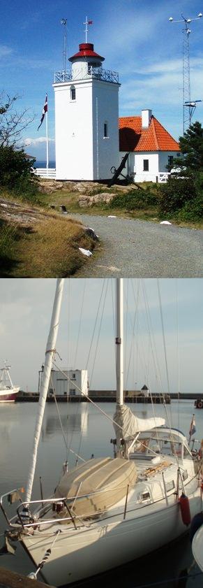
Isabell in the fishing harbour Tejn, Bornholm, the farthest destination of this summers trip
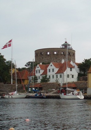
And on the way homeward we stopped at the Danish stronghold Christiansoe, well worth a visit
© Johannes C. Knulst, 2008-2025
From January 2019 this site is upgraded with PHP-version 7.3 and MYSQLi compatibility.
SV Isabell is an excellent long-range sailing vessel for single handed sailing or small family expeditions. Safe, sound, and well built. With a D/L ratio of 342 this 31-foot boat gives a comfortable ride, wherever you sail.
